Beneath the Surface: A Deep Dive Into Geophysical Technologies for Sustainable Engineering

As climate-related events continue to become more common and more extreme, understanding the environment and how to preserve it is paramount. One way to increase our climate resilience is to better understand what is happening beneath the Earth’s surface. Geophysics investigates the physical processes and properties of our planet below the ground’s surface.
The landscape of geophysics is ever evolving and has experienced a rapid technological expansion over the last few years. Among these advancements are several geophysical options for two-dimensional (2D) and three-dimensional (3D) subsurface modeling: multi-channel analysis of surface waves (MASW) surveys, electrical resistivity surveys, seismic refraction surveys, and refraction microtremor (ReMi) surveys. These technologies are used to gather data on the physical properties, composition, and structure of the Earth’s subsurface, providing vital information related to the distribution of various geological features.
MASW Surveys: Unveiling Subsurface Velocity
The MASW technique is used to determine the shear wave velocity profile of the subsurface with unparalleled accuracy. This non-invasive method enables us to create a 2D slice of the subsurface, determine the stiffness of subsurface soils, and map the depth of bedrock by correlating the speed at which sound waves (shear waves) travel through the different subsurface medium. This technique allows us to provide bearing capacities, identify areas of glacial till, map bedrock elevations, and determine several other engineering properties without penetrating the ground’s surface.
This process is especially helpful in adaptive reuse projects where a typical geotechnical investigation cannot take place, inside of an existing building, and in difficult-to-access areas. Since this technique is completely non-destructive, mobile enough to go anywhere a person can walk to, and does not require the use of gas-powered equipment, we can perform these surveys in areas where traditional drill rigs cannot access and provide a far less destructive testing method.
Electrical Resistivity Surveys: Peering Into Subsurface Electrical Properties
Electrical resistivity surveys are used to detect differences in the electrical properties of the subsurface, enabling us to map variations in soil moisture content, geological structures, and groundwater levels. We can integrate this technique to gain invaluable insights and make informed decisions across a range of project types, optimizing resource management and minimizing unforeseen risks.
With this technique, we can correlate the results of soil borings over hundreds of feet, allowing us to reduce the unknowns between distant soil borings. Additionally, as the go-to geophysical approach for identifying sinkhole development and water intrusion issues, this technique can be used for solar array projects in sinkhole-prone areas to further identify, delineate, and mitigate sinkhole risk.
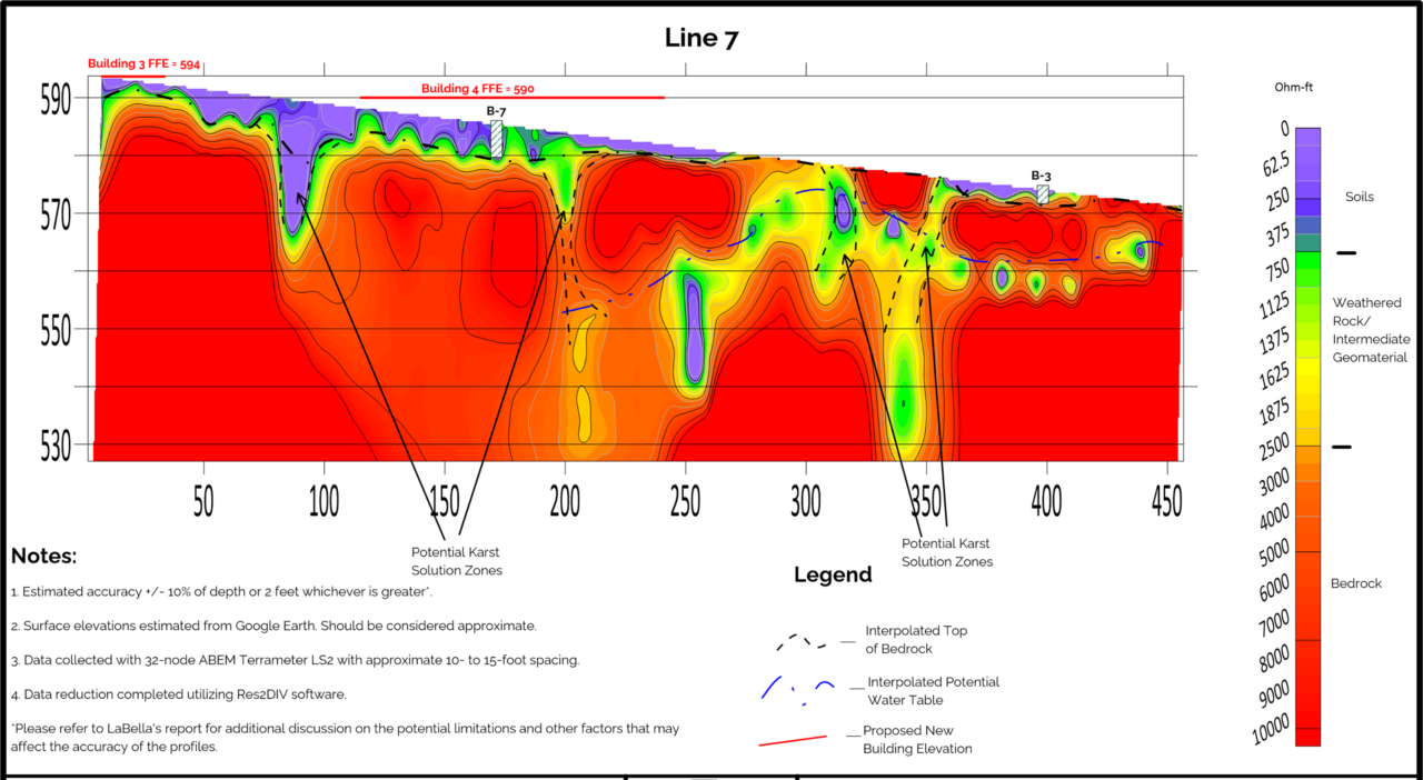
*A profile from a proposed multi-family apartment complex in Tennessee. The profile was completed to identify potential karst/sinkhole areas as several possible sinkholes had been identified in the surrounding area. The profile shows very undulating bedrock that correlated with the standard penetration test borings shown. Multiple potential solution zones along with a potential perched water table were also identified in the survey.
Seismic Refraction Surveys: Identifying Rock Layers
Seismic refraction surveys measure the velocity of seismic waves (P waves) as they traverse different materials. This method is instrumental in delineating bedrock depths and is the best way to determine the overall rippability of weathered bedrock quickly over large areas. Depending on the measured shear wave velocities, there are numerous studies that correlate the shear wave velocity of different bedrock materials and the size of excavation equipment that can rip the weathered rock.
The use of seismic refraction surveys can enhance the accuracy of geological models, leading to more precise engineering designs that avoid rock outcrops and more effective mitigation of potential hazards. This enables contractors to utilize more efficient construction equipment, reducing the overall carbon footprint of projects.
ReMi Surveys: Unveiling Subsurface Layers
The ReMi survey method measures the surface waves generated by microtremors and analyzes their dispersion characteristics to determine the shear wave velocity of the subsurface. This non-invasive, cost-effective approach is typically utilized in determining seismic site classifications. Following the release of the 2024 International Building Code, seismic site classification is solely based on shear wave velocity measurements that can be collected using a ReMi survey.
Often, by measuring seismic site classifications using shear wave velocity, less conservative seismic site classifications are identified when compared to using N-value analysis. This can lead to significant savings on the overall construction cost as certain seismic bracing components can be reduced or eliminated.
The Intersection of Innovation and Engineering
These cutting-edge geophysical capabilities redefine the limits of what we can uncover beneath the Earth’s surface, offering a deeper understanding of the ground beneath us and opening avenues for more precise engineering solutions. Embracing these new geophysical techniques signifies a commitment to pushing the boundaries of traditional geotechnical engineering.
By integrating MASW, electrical resistivity, seismic refraction, and ReMi surveys into our approach, LaBella remains ready to deliver comprehensive solutions, ensuring the efficiency, safety, and sustainability of our projects. These advancements not only enhance our capabilities but also reinforce our dedication to delivering excellence in every project we undertake. As we continue to evolve, these methodologies serve as the cornerstone of our commitment to precision, innovation, and excellence in the field of engineering.
Land Surveying Services Expand in the Carolinas
A growing team of skilled survey professionals in LaBella’s Rock Hill, South Carolina, office is now offering comprehensive land surveying solutions across North Carolina and South Carolina. Our licensed land surveyors specialize in boundary and topographic surveys essential for land acquisition and development, as well as design surveys for new infrastructure projects or rehabilitation of existing infrastructure.
Our teams also perform ALTA/NSPS surveys, GPS control surveys, FEMA elevation and flood zone surveys, land subdivision, construction surveying support, deformation and monitoring surveys, utility surveys, as-build surveys, differential and digital leveling, and wetland surveys and mapping.
The addition of land surveying in Rock Hill further solidifies our role as a comprehensive, full-service consultant for our clients throughout the Carolinas.
Learn more about our surveying capabilities and experience by clicking below.
surveying capabilities and experience