NYSOGS Harriman Campus GIS Pilot
A Simple Land Survey Is Transformed Into a Digital Utility Assets Map, Making Utility Location on a Large Campus Easier and Quicker

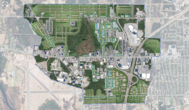
 Under a Land Surveying Term Agreement with the New York State Office of General Services (NYSOGS), LaBella completed a boundary survey of the 350-acre Harriman State Office Campus in Albany, New York. We also completed a detailed topographic survey and underground utility mark out to support site design and construction using Leica Dual Frequency GPS Receivers to complete the initial control survey on NAD 83 and NAVD 88 datums. Leica Robotic Total Station was utilized to complete the instrument survey and final mapping was prepared in AutoCAD Civil 3D format.
LaBella’s Data Intelligence team converted this data into a user-friendly, GIS-based application that now provides NYSOGS direct access to the locations and details of their utility assets while in office or in the field. Our team began by analyzing and incorporating the CADD-based drawings that were generated from the survey and underground utility mark out. This data was organized by utility type, combined into one authoritative geodatabase, and integrated into an industry standard Esri ArcGIS Online platform.
The result? An easy-to-use digital map that NYSOGS project managers can use to view the locations and information of utility assets while in the office. Field staff can also use Esri’s Field Maps mobile application to access the maps while out on the campus. For the next steps, we can use the application with other in-house work order tools to further integrate GIS and mapping with their business processes.
What We Did
CADD to GIS Conversion
LaBella’s Data Intelligence team converted the AutoCAD layers representing surveyed locations of utility assets such as water lines, valves, hydrants, and storm and sewer lines with associated manholes, catch basins, etc. As data from the survey was incorporated into a new Enterprise GIS Geodatabase, we also captured metadata representing the accuracy of the saved data (surveyed exact location, record drawings, etc.).
Online Mapping
Our team then utilized Esri technology to develop an online web mapping interface to present this data to NYSOGS staff. Utilizing ArcGIS Online and ArcGIS Web Apps, we built a comprehensive mapping solution that enables NYSOGS to view their utility asset data in a web browser format. This included the development of custom attribute displays to highlight for staff the most important attribute information.
Field Access / Augmented Reality
Using Esri’s ArcGIS Collector, LaBella provided access to utility data in the field for on-site crews. The Collector GIS map paired with a Trimble TDC600 provides access to view the data in an “augmented reality” format. Crews can utilize this app to locate utilities, even in adverse conditions (nighttime, snow, etc.).
Data Markup Tools
NYSOGS staff has the ability, both on desktop and in the field, to submit “points of interest” for identifying noteworthy items in the field that are not included in the GIS data as well as for identifying areas where mapping layers need to be updated or fixed. In office teams then use this information for making the changes.